







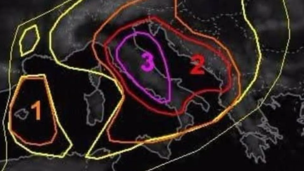
Tuscany enters the most delicate hours of this new wave of bad weather that has led the Region to declare an orange alert for thunderstorms for the first part of Sunday, July 26. On the afternoon of Saturday, July 25, the Tuscany Weather Center released an analysis based on the latest emission of the European model Estofex, one of the most authoritative systems in predicting extreme events. And the picture that emerges is one that requires maximum attention. «The Estofex analysis center – explains the Tuscany Weather Center – has just issued a level 3 alert for strong thunderstorms that also partly affects our region». An alert level that, for experts, represents a critical threshold: Estofex uses it only in the presence of conditions favorable to the development of particularly intense phenomena, such as organized squall lines, downbursts and large hailstorms.
️The 2022 precedent and the risk of extreme phenomena
The analysis recalls that a level 3 alert is not a frequent event. «The last time this also affected our region – explains the Cmt again – was August 18, 2022». In that circumstance, the famous Derecho developed, a storm structure that crossed half of Europe with devastating winds, causing twelve victims and over one hundred injured. Two of those deaths occurred in Tuscany, in Carrara and Lucca. The reference to that episode serves to contextualize the scope of the alert: when Estofex issues a level 3, the probability of violent phenomena cannot be underestimated.
What awaits Tuscany in the coming hours
According to the analysis, the most critical phase will begin in the late evening. «From the evening, we expect the formation of an intense Squall Line west of Corsica moving northeast with an expected impact on the provinces of Massa-Carrara, Lucca, Pistoia and northern Pisa area immediately after midnight», the Cmt reports. A Squall Line, or a linear thunderstorm front, is one of the most dangerous configurations: it can generate thousands of lightning strikes, violent downpours, and sudden wind gusts. The expected passage between Versilia, Massa Carrara, and the north-western coast could bring localized cloudbursts and downbursts, i.e., descending wind gusts capable of causing significant damage.
️The most exposed and least affected areas
The analysis continues by indicating a very irregular distribution of phenomena. «The thunderstorms that will then move towards the Prato area, Pistoia area and northern Florence area – analyzes the Cmt – but probably somewhat attenuated. Low probability of hail. Little to nothing south of Livorno». The southern part of the region, therefore, should be only marginally affected during the night, while the northern provinces remain in the most exposed quadrant.
Sunday morning: risk of giant hail in southern Tuscany
Sunday, July 26, will open with a new phase of instability, this time concentrated in the central-southern sector. «On the morning of Sunday, July 26 – explains the Cmt again – the development of new intense thunderstorms is expected between the lower Livorno area and the Grosseto area with intense downpours moving towards the provinces of Arezzo, Siena and inner Grosseto area». In these areas, the risk is high: thunderstorms could reach strong intensity, with wind gusts and the concrete possibility of giant hail, a phenomenon that has repeatedly affected inland Tuscany in recent years. Rainfall accumulations, according to the analysis, could reach 70-100 millimeters in a short time, values that can generate hydraulic criticalities and sudden floods.
️Widespread instability elsewhere
The rest of the region will experience a variable Sunday, with scattered but less intense showers compared to the most exposed areas. «In other areas – specifies the Cmt – unstable with possible scattered showers but less intense and less lasting than the areas mentioned above». With an Estofex level 3 alert and a forecast indicating violent phenomena, it is advisable to avoid travel during the most critical hours, pay attention to underpasses, depressed areas, and coastal areas most exposed to wind gusts.
Read more Weather in Tuscany, violent thunderstorms arriving: orange alert – The critical areas and hours
The evolution from radar
Below is the evolution from the radar (from the sector website Windy)