








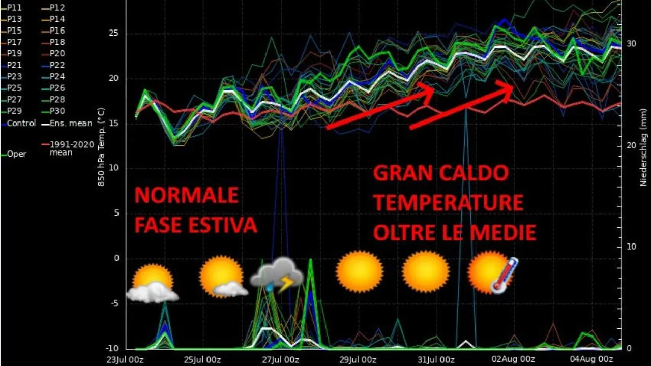
The Tuscan Weather Center, in its analysis released on the morning of Thursday, July 23, outlines a detailed picture of the atmospheric evolution expected in our region. A reading that starts from a graph re-elaborated by the CMT and clearly summarizes the trend of precipitation and temperatures in the coming days.
Read more Benessity Conad, in Florence the first store in Italy entirely dedicated to well-being
The explanation
“The weather of these days can be summarized in this re-elaborated graph (visible in the photo, editor’s note). In the lower part – explains the Tuscan Weather Center – there are the probabilities of precipitation, in the upper part the thermal values at 850 hpa, or 1500 meters above sea level in the free atmosphere. The graph refers to Arezzo, so we are in central-eastern Tuscany. The red line is the thirty-year reference average: 1991-2020, already one of the warmest compared to previous ones.” According to the CMT, the current phase is fully summer, with normal conditions and some slight upward deviation in maximum temperatures. A situation that is not surprising, especially considering the cool minimums recorded in some Apennine areas. “This summer phase, between Thursday, July 23 and Saturday, July 25, is all in all normal, even if some maximums exceed 30 degrees, therefore slightly above average. On the other hand, in some Apennine valley floors, minimums of 10-11 degrees were reached on the morning of Thursday, July 23, cool values but certainly not unusual for these areas,” the CMT further explains.
Instability before the sun
The Tuscan Weather Center reports for Thursday, July 23, the possibility of some convective phenomena in the central-eastern internal areas, while the situation will tend to stabilize between Friday and Saturday. “For Thursday, July 23, in the central-eastern internal areas, convective cloudiness will be possible, more likely in the afternoon/evening, and some scattered and isolated showers can be expected. Friday, July 24 and Saturday, July 25, stable and sunny weather with normal thermal values for the period or a little above average.”
️Rain from the west
The worsening expected for Sunday, July 26, although scaled down in the latest elaborations, should still bring instability to Tuscany. A dynamic that will be better defined in the coming hours. “On Sunday, the arrival of a low-pressure system from the west is expected, which with the passing of forecast elaborations has become increasingly ‘weak’ but which will still be able to bring instability to our region. We will then see in detail, close to the event, which areas will be most affected,” continues the Tuscan Weather Center.
Then the rise
The most significant part of the analysis, however, concerns the following week, from Monday, July 27, when Tuscany could be affected by a more marked heatwave, with values even above 35 degrees. A prospect that divides enthusiasts: there are those who await intense heat and those who fear it. “We are again expecting thermal values above 35 degrees. The graph is clear and all clusters (the ‘spaghi’, editor’s note) show a clear rise. The reason is always the same – explains the Tuscan Weather Center in conclusion – namely a deepening of an Atlantic trough towards the west of the Iberian Peninsula, over the eastern Atlantic, and the simultaneous rise of a high-pressure ridge towards the central-western Mediterranean.”
Read more Another tragedy in the pool, 5-year-old child dies in Monterotondo